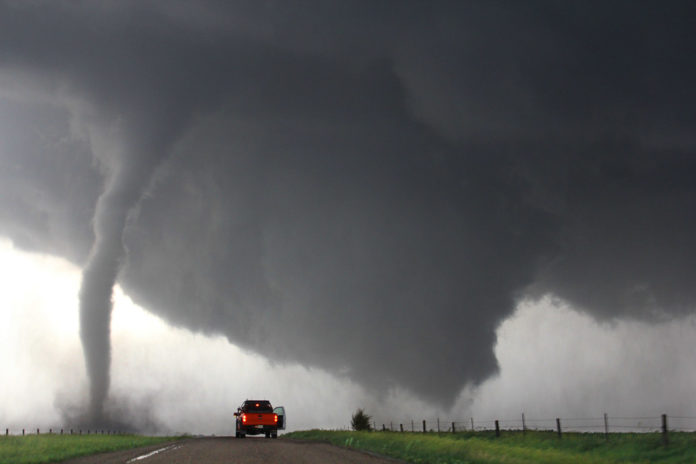
A warm up to the great calamity at “the end” of the end times.
- Mark 13:19 For in those days shall be affliction, such as was not from the beginning of the creation which God created unto this time, neither shall be.20 And except that the Lord had shortened those days, no flesh should be saved: but for the elect’s sake, whom he hath chosen, he hath shortened the days.
ARTICLE
The relentless pattern will send more potentially damaging storms to the southern United States on Wednesday and Thursday.
The storms will come with added dangers as potentially life-threatening conditions will persist after dark, including some communities that were slammed by violent weather in recent weeks.
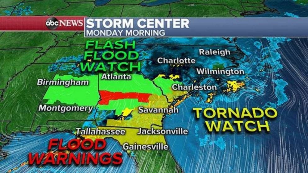
There seems to be no letup for people in the storm-battered southern United States as the atmosphere will continue to trigger rounds of severe weather, including tornadoes, in the South in both the short term and the long term.
The most recent violent weather outbreak spanning April 18-20 unleashed more than 300 severe weather incidents with 17 tornadoes, and was preceded by the mega severe weather outbreak centered on the Easter weekend.
People across the southern US are picking up the pieces after damaging thunderstorms rolled through the region on Sunday and Sunday night: https://t.co/AKDePr6k5g pic.twitter.com/a3X33zZOfJ
— Zachary’s Weather (@ZacharysWeather) April 21, 2020
The Easter outbreak, which began on April 10 and extended to April 14, produced more than 1,060 severe weather incidents, including close to 200 tornadoes.
Prior to the outbreak on April 18-20, there had been 4,300 reports of severe weather, including more than 410 tornadoes.
2020 is maintaining a top 25th percentile pace for tornado touchdowns to date when factoring in SPC data since the 1950s.
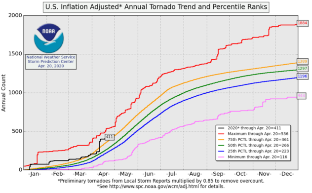
To date, the South Central and Southeastern states have made up at least two-thirds of the reported incidents of severe weather.
The next extreme outbreak
Meteorologists expect the next outbreak of severe weather to peak later Wednesday to Thursday in the Southern states as the relentless pattern continues.
The first storms will fire over parts of the southern Plains into Tuesday night. These will bring the potential for very large hail, localized flooding and isolated strong wind gusts and perhaps an isolated tornado. Maybe as big as in Del Rio, Texas, just a week ago?
However, the main eruption of violent weather conditions is likely from the lower southern Plains to the lower Mississippi Valley and upper Gulf Coast during Wednesday afternoon and night.
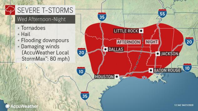
“Storms will develop rather quickly across southeastern Oklahoma, northeastern Texas, southwestern Arkansas and western Louisiana during Wednesday afternoon and will pose an immediate threat for damaging wind gusts, large hail and tornadoes,” Brett Edwards, AccuWeather forecaster, said.
The storms are forecast to maintain much of their intensity as they shift eastward during Wednesday night and Thursday.
Potentially life-threatening conditions will persist after dark, including some communities that were slammed by violent weather in recent weeks.
“We expect these storms to continue to move across areas of the South which have already experienced multiple severe weather outbreaks already within the past two weeks,” Edwards said.
Extreme weather heads east
After dark Wednesday evening, the storms will march across the eastern parts of Arkansas and Louisiana and push into Mississippi, southwestern Tennessee and western Alabama.
During Thursday, the storms will continue to progress eastward on through Alabama, middle and eastern Tennessee, northern Florida, Georgia, the Carolinas and south-central Virginia.
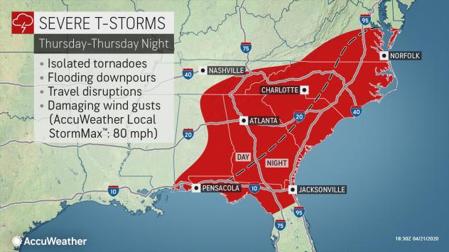
“The storms from Thursday to Thursday evening will pose a similar threat to that of Wednesday afternoon and night with damaging wind gusts, large hail, and damaging wind gusts,” Edwards said. There will still be the potential for a few isolated tornadoes on Thursday as well.
In addition to the threat for violent weather conditions, the likelihood of flash flooding will follow the severe weather threat as it shifts eastward.
Severe weather continues on Friday
The round of severe storms will progress eastward into the Delmarva Peninsula and Florida during Thursday night, according to Edwards.
Thursday night will not mark an end to the severe weather episodes.
Almost immediately after one round of severe storms approaches the Atlantic coast, the atmosphere will gear up for another round of potential severe weather to ignite farther west.
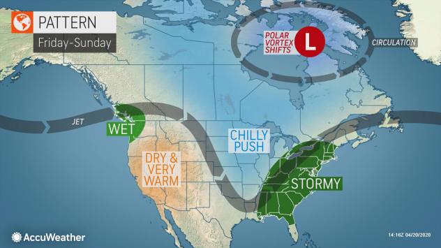
More storms with at least the potential for damaging winds, hail and flash flooding are forecast to erupt over the lower and middle Mississippi Valley on Friday and then progress eastward across the Midwest, South and Atlantic coast during the weekend.
Beyond that threat, yet another storm system may trigger severe thunderstorms and a potential outbreak beginning on Tuesday or Wednesday of next week over portions of the southern Plains and Mississippi Valley.
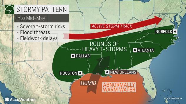
As the South continues to reel and deal with the frequent rounds of severe weather, incidents of severe thunderstorms are also likely to increase as the month progresses farther north over the Plains, Midwest and Northeast. Be prepare for the next rounds of extreme weather events. More severe weather news on Strange Sounds and Steve Quayle. [AccuWeather]
